![](/images/other/stat-length.png)
![Tocht Stappen Le Pin-au-Haras - Versailles du cheval - Le Pin au Haras - Photo](https://media.geolcdn.com/t/1900/400/ext.pjpeg?maxdim=2&url=https%3A%2F%2Fservices.sitytrail.com%2FGeolivesWS%2FDownloadMedia.ashx%3FTrailID%3D111666%26Media%3D7904_2.jpg)
Versailles du cheval - Le Pin au Haras
tracegps
Gebruiker
![Lengte](/images/other/stat-length.png)
Lengte
6,9 km
![Max. hoogte](https://static1.geolcdn.com/siteimages/upload/files/1508320355ic_sort_altitude_max_24dp.png)
Max. hoogte
251 m
![Positief hoogteverschil](https://static1.geolcdn.com/siteimages/upload/files/1508320355ic_sort_den_pos_24dp.png)
Positief hoogteverschil
114 m
![Km-Effort](/images/other/stat-length.png)
Km-Effort
8,4 km
![Min. hoogte](https://static1.geolcdn.com/siteimages/upload/files/1508320355ic_sort_altitude_min_24dp.png)
Min. hoogte
175 m
![Negatief hoogteverschil](https://static1.geolcdn.com/siteimages/upload/files/1508320355ic_sort_den_neg_24dp.png)
Negatief hoogteverschil
114 m
![Boucle](https://static1.geolcdn.com/siteimages/upload/files/16400158638029165_repeat_loop_refresh_sync_direction_icon.png)
Boucle
Ja
Datum van aanmaak :
2014-12-10 00:00:00.0
Laatste wijziging :
2014-12-10 00:00:00.0
![Stappen](https://static1.geolcdn.com/sitytour/trail-icons/101.png)
2h19
Moeilijkheid : Medium
![Scan deze QR-code om de tocht te openen in de SityTrail-applicatie](https://capi.geolives.com/qq0zvz2zws4bq2lad0pu/sitytour/trails/111666/qr.png?size=200)
Gratisgps-wandelapplicatie
Over ons
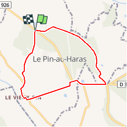
Tocht Stappen van 6,9 km beschikbaar op Normandië, Orne, Le Pin-au-Haras. Deze tocht wordt voorgesteld door tracegps.
Beschrijving
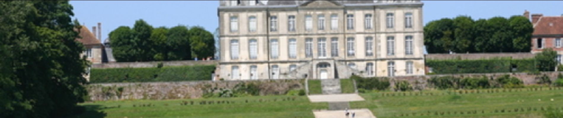
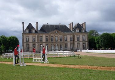
Versailles du cheval - Le Pin au Haras. Au pays du cheval et des haras, découvrez le site du prestigieux Haras National du Pin, véritable "Versailles du Cheval". Retrouvez les Coup de Cœur Randonnée dans l’Orne en Normandie.
Plaatsbepaling
Land:
France
Regio :
Normandië
Departement/Provincie :
Orne
Gemeente :
Le Pin-au-Haras
Locatie:
Unknown
Vertrek:(Dec)
Vertrek:(UTM)
289309 ; 5403767 (31U) N.
Opmerkingen
Wandeltochten in de omgeving
![Tocht Mountainbike Gouffern en Auge - Randonnée VTT - Le Bourg Saint Léonard - Photo](https://media.geolcdn.com/t/375/260/ext.jpg?maxdim=2&url=https%3A%2F%2Fservices.sitytrail.com%2FGeolivesWS%2FDownloadMedia.ashx%3FTrailID%3D214869%26Media%3D15415_1.jpg)
![Mountainbike Mountainbike](https://static1.geolcdn.com/sitytour/trail-icons/202.png)
Randonnée VTT - Le Bourg Saint Léonard
Mountainbike
Moeilijk
(1)
Gouffern en Auge,
Normandië,
Orne,
France
![](/images/other/stat-length.png)
43 km | 53 km-effort
2h 30min
![](https://static1.geolcdn.com/siteimages/upload/files/16400158638029165_repeat_loop_refresh_sync_direction_icon.png)
Ja
![Tocht Paard Gouffern en Auge - Boucle du Bourg-St-Leonard - Photo](https://media.geolcdn.com/t/375/260/ext.jpg?maxdim=2&url=https%3A%2F%2Fservices.sitytrail.com%2FGeolivesWS%2FDownloadMedia.ashx%3FTrailID%3D112044%26Media%3D9572_2.jpg)
![Paard Paard](https://static1.geolcdn.com/sitytour/trail-icons/300.png)
Boucle du Bourg-St-Leonard
Paard
Moeilijk
Gouffern en Auge,
Normandië,
Orne,
France
![](/images/other/stat-length.png)
20 km | 23 km-effort
5h 0min
![](https://static1.geolcdn.com/siteimages/upload/files/16400158638029165_repeat_loop_refresh_sync_direction_icon.png)
Ja
![Tocht Stappen Le Pin-au-Haras - Le Haras du Pin - Photo](https://media.geolcdn.com/t/375/260/ext.jpg?maxdim=2&url=https%3A%2F%2Fstatic1.geolcdn.com%2Fsiteimages%2Fupload%2Ffiles%2F1553511878bg_sport_marche.png)
![Stappen Stappen](https://static1.geolcdn.com/sitytour/trail-icons/101.png)
Le Haras du Pin
Stappen
Medium
Le Pin-au-Haras,
Normandië,
Orne,
France
![](/images/other/stat-length.png)
29 km | 34 km-effort
6h 28min
![](https://static1.geolcdn.com/siteimages/upload/files/16400158638029165_repeat_loop_refresh_sync_direction_icon.png)
Ja
![Tocht Stappen Le Pin-au-Haras - La Boucle du Pin - Photo](https://media.geolcdn.com/t/375/260/ext.jpg?maxdim=2&url=https%3A%2F%2Fstatic1.geolcdn.com%2Fsiteimages%2Fupload%2Ffiles%2F1553511878bg_sport_marche.png)
![Stappen Stappen](https://static1.geolcdn.com/sitytour/trail-icons/101.png)
La Boucle du Pin
Stappen
Gemakkelijk
Le Pin-au-Haras,
Normandië,
Orne,
France
![](/images/other/stat-length.png)
6,8 km | 8,4 km-effort
2h 0min
![](https://static1.geolcdn.com/siteimages/upload/files/16400158638029165_repeat_loop_refresh_sync_direction_icon.png)
Ja
![Tocht Stappen Gouffern en Auge - Bourg St Leonard (boucle) - Photo](https://media.geolcdn.com/t/375/260/ext.jpg?maxdim=2&url=https%3A%2F%2Fstatic1.geolcdn.com%2Fsiteimages%2Fupload%2Ffiles%2F1553511878bg_sport_marche.png)
![Stappen Stappen](https://static1.geolcdn.com/sitytour/trail-icons/101.png)
Bourg St Leonard (boucle)
Stappen
Medium
Gouffern en Auge,
Normandië,
Orne,
France
![](/images/other/stat-length.png)
20 km | 24 km-effort
5h 0min
![](https://static1.geolcdn.com/siteimages/upload/files/16400158638029165_repeat_loop_refresh_sync_direction_icon.png)
Ja
![Tocht Stappen Le Pin-au-Haras - Le Haras du Pin 6.8 Km - Photo](https://media.geolcdn.com/t/375/260/ext.jpg?maxdim=2&url=https%3A%2F%2Fstatic1.geolcdn.com%2Fsiteimages%2Fupload%2Ffiles%2F1553511878bg_sport_marche.png)
![Stappen Stappen](https://static1.geolcdn.com/sitytour/trail-icons/101.png)
Le Haras du Pin 6.8 Km
Stappen
Heel gemakkelijk
Le Pin-au-Haras,
Normandië,
Orne,
France
![](/images/other/stat-length.png)
6,8 km | 8,4 km-effort
1h 49min
![](https://static1.geolcdn.com/siteimages/upload/files/16400158638029165_repeat_loop_refresh_sync_direction_icon.png)
Ja
![Tocht Stappen Le Pin-au-Haras - Haras du Pin 23 - Photo](https://media.geolcdn.com/t/375/260/ext.jpg?maxdim=2&url=https%3A%2F%2Fstatic1.geolcdn.com%2Fsiteimages%2Fupload%2Ffiles%2F1553511878bg_sport_marche.png)
![Stappen Stappen](https://static1.geolcdn.com/sitytour/trail-icons/101.png)
Haras du Pin 23
Stappen
Medium
Le Pin-au-Haras,
Normandië,
Orne,
France
![](/images/other/stat-length.png)
23 km | 28 km-effort
6h 6min
![](https://static1.geolcdn.com/siteimages/upload/files/16400158638029165_repeat_loop_refresh_sync_direction_icon.png)
Ja